Soil Moisture Map (similar heatMap widget but only for soilMoisture)
Dear Tago Team,
I would like to have a widget, similar to the heatmap but that controls soil moisture based on the data logging sent by the sensor.
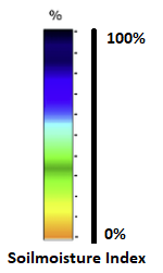
The value in the scale must be from 0 to 100%, using the colors as shown in the image (Soilmoisture Index)
As background you could use an image of the map seen from the satellite in static mode (jpg o png image or http link), or use openstreetmap.org and enter the exact point using the sensor coordinates sent in the sensor metadata.
The new widget will have the name: Soil moisture Map, very useful for precision agriculture but also for controlling soil moisture in lawns and public parks
Topic Participants
Gabriele Foddis
Phil Gutierre
r.juch
Carolina Hidalgo